A Quick Visit to Mount Rainier

It has been a busy few months – it is hard to believe that 2025 is now half over! Does anyone else feel like this year is flying by, or is it just me?

But in all seriousness, between local hikes and adventures, as well as trips to the United Stated, Europe and Galiano Island, I have a lot to write about. But, I am going to start with our most recent trip to Mount Rainier National Park as it is currently fresh in my head!

Our trip to Mount Rainier National Park was booked pretty last minute – we had some extra time off from work, and found accommodation available near the park entrance… so we went for it! 

The drive from our home to Ashford, Washington was about five hours long. This included our wait time at the border, and we also made a couple of stops along the way, one of them being our mandatory stop at Trader Joes (in Bellevue). If you have read my other blog posts, you will know that all of our trips to the United States involve a visit (or multiple visits) to Trader Joes. Here, we picked up a couple of premade meals, along with snacks and all the fixings for making sandwiches. 

Our accommodation in Ashford was a cute, small cabin located just 9-minutes from Mount Rainier’s Nisqually Entrance. We arrived here on Saturday afternoon around 2:30pm, quickly dropped-off all our stuff and changed before heading off to the park.

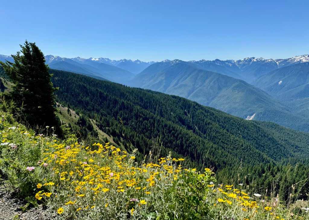
For our first partial day in the park, we decided to do the Comet Falls via Van Trump Trail. This trail is located about 30-minutes past the park entrance. I will note that because we were entering the park quite late in the day (3:00pm), there was only a small line-up of cars in front of us. 

The drive towards the trail was down a windy road, mostly in a forested area, and there are no views of Mount Rainier, itself, from this part of the park. Speaking of Mount Rainier, it was not until after we arrived at the park that I learned Mount Rainier is an active volcano – it is a bit scary to think about! But, I digress…

While our research warned us that the parking lot for Comet Falls was small, we did not realize just how few spots would be available! The pull-out on the side of the road has room for around 15 vehicles, which were all taken when we arrived, forcing us to park on the side of the road. Pro tip: If you find yourself in a situation where you need to park on the road, make sure your tires are behind the white line, otherwise you will receive a violation notice. We saw many vehicles with orange tickets stuck to their window!

Anyway, after parking, changing into our hiking shoes, and grabbing our backpacks and hiking poles, it was time to start the trail. The Comet Falls via Van Trump Trail is rated hard on AllTrails – it is about 5.6km in length, and apparently has an elevation gain of 392m. However, my activity for this trail in the AllTrails application indicated that I completed 549m in elevation gain – I do not know which one is correct… let’s split the difference! Either way though, I agree with this rating – the trail is difficult as it has a steady incline all the way to the main falls. There are very few flat areas on the trail, and there are also a lot of rocks and tree roots to navigate.

However, do not let this rating deter you – the views are all worth it! 

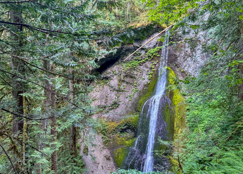
Soon after starting the trail (while you are still near the main road), you will be rewarded with views of Christine Falls, which is a much smaller waterfall compared to Comet Falls. After this, you will enjoy a peaceful walk through the forest before reaching a rocky opening on the trail. I found this to be the most difficult part of the trail, mostly due to the uneven ground, the heat (since there is no shade), and there was also a tree that had fallen onto the trail that you have to climb over or under. But, we persevered!

Christine Falls along the Comet Falls via Van Trump Trail

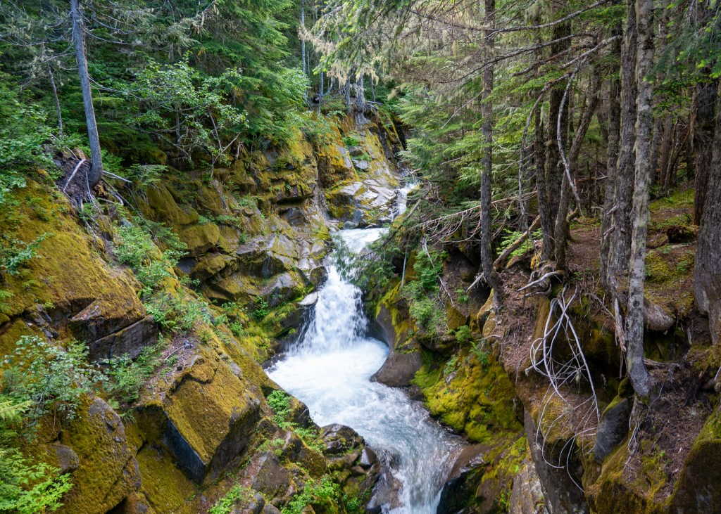
After the rocky opening, you will once again enter the forest, and after a series of small switchbacks, you will turn the corner and be greeted by Comet Falls. 

One word: Wow. This was probably my favourite view of the Falls – nestled amongst the mountains and trees, with the water flowing through the valley. 

My favourite view of Comet Falls

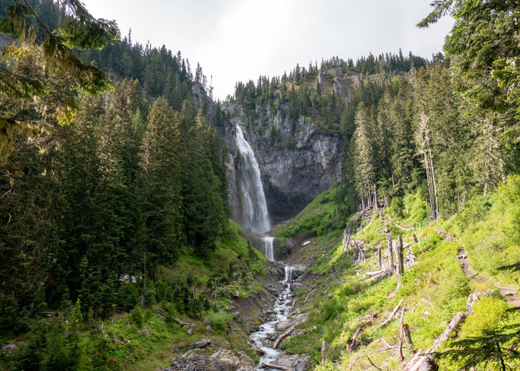
After taking in the Falls from this view point, we continued along the trail to the very end, where we got close and personal with it – I could feel the water spraying me, which was actually very refreshing! 

Given that it was quite late in the day by the time we finished the Comet Falls trail, we decided to head back to our accommodation and eat, before heading to bed – we were getting up early the next day to do the Skyline Loop.

According to AllTrails, the Skyline Loop is the number one trail in the park. This hike is 9km long, and has an elevation gain of 542m. The trail took us a total of 4-hours and 20-minutes to complete, including the many stops we took to eat and take photos, but our actual walking time was 3-hours and 15-minutes, which is very comparable to the AllTrails estimate. 

Our research indicated that the parking lot near the Skyline Loop trailhead fills-up quickly. For this reason, we left our Airbnb at 6:45am, and arrived at the parking lot around 7:30am, and by this time, the lot was nearly half full! The Jackson Visitor Centre is also located near the trailhead, but take note that there is a separate parking lot for hikers – the Visitor Centre parking has a limit of 2-hours.

The Skyline Loop starts off on paved concrete, which made me think we were getting off to an easy start. But do not be fooled – while the path might be paved, there is an immediate incline. This, combined with the fact that the trailhead starts at 5400ft above sea level, made for a difficult start to this hike. I have noticed a couple of times now from our trips to other National Parks that I have difficulty breathing (while hiking) at higher elevations. Is it just me? 

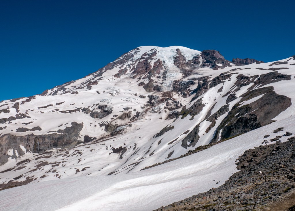
Anyway, it was not long before we were unable to see the concrete beneath us – we encountered snow, and lots of it! Even though it was late June, our visit to Mount Rainier was still considered to be the shoulder season. And, given the high elevation, it was no surprise that the trail was still predominantly covered in snow. Fortunately, we came prepared with crampons and hiking poles. I would not have been successful on this trail without these items – we saw many people slipping and sliding in the snow.

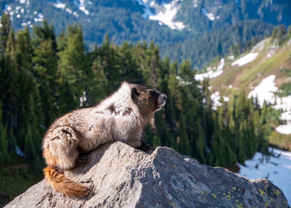
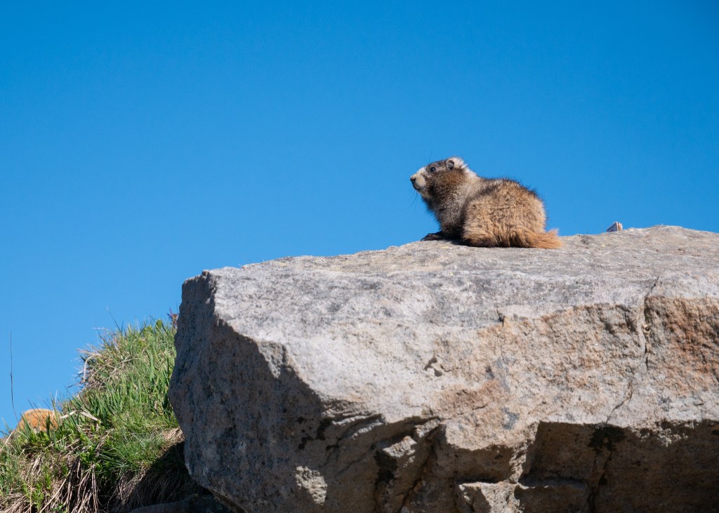
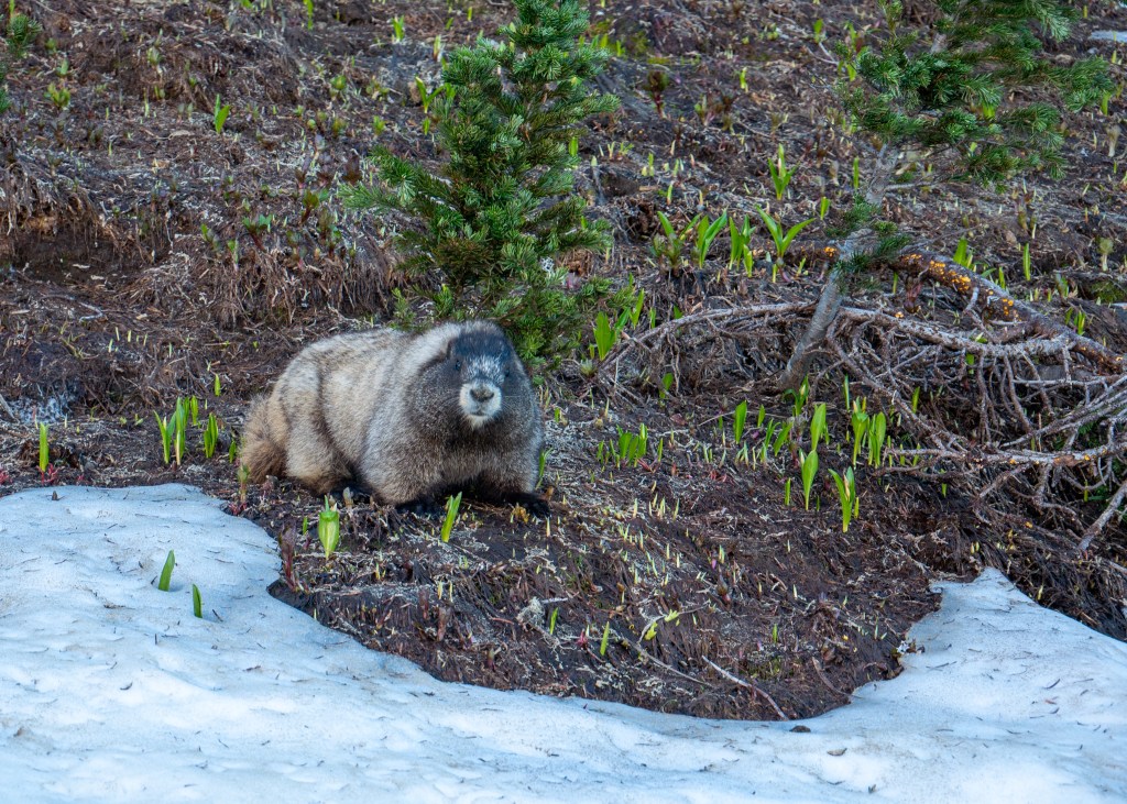
Shortly after we started the trail, we came across marmots! A couple of them were sunbathing on the rocks, while others were looking for food. We actually saw marmots multiple times throughout the hike. Our favourite encounter was when we saw them “in action.” I say it like this because it was not clear to us if they were playing, or fighting – but either way, it was very entertaining to watch. At one point, one of the marmots stopped playing/fighting, laid down and did not move for several minutes – we got a bit concerned. But not long after, we noticed the marmot had moved, and was making a mad dash across the snow-covered hills! 

A marmot sunbathing ツ

Some hikers we talked to on the trail apparently also saw a bear, but we did not see any other wildlife aside from marmots and a couple of deer at the other end of the trail.

Another marmot sunbathing
Okay, last marmot picture

The views along the trail, especially of Mount Rainier, were absolutely stunning. I found myself stopping to take photos every few minutes – which definitely contributed to the extra hour of our non-hiking walking time. There were also amazing views of other nearby mountains along the trail – Mount St. Helens, Mount Adams and even Mount Hood which is located in Oregon. The best views of these three neighbouring mountains was from Panorama Point, which is located around 3km from the start of the trailhead. 

The mighty Mount Rainier
Views of Mount Adams from Panorama Point; Mt Hood is also visible in the distance

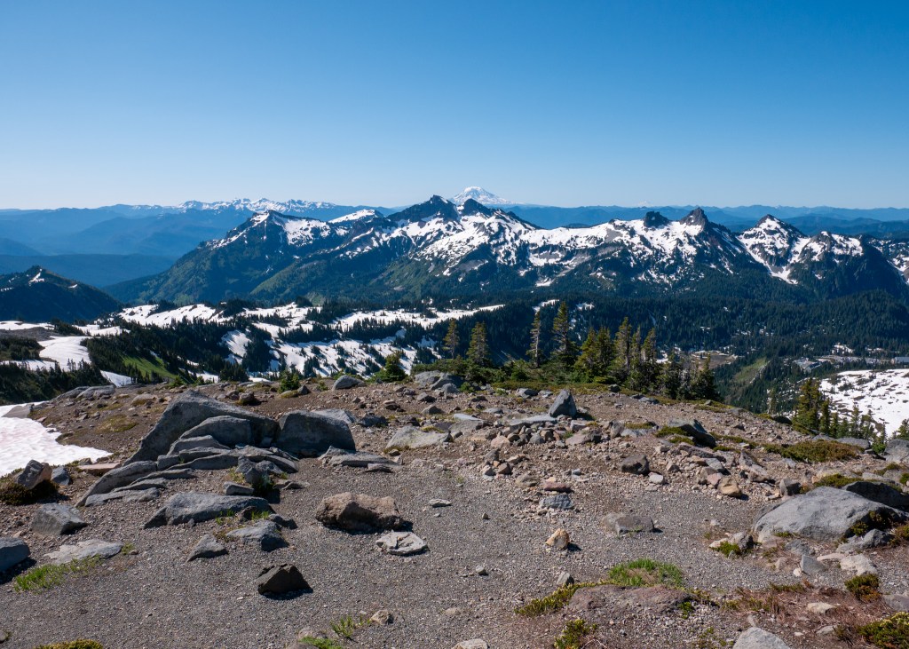
By far, the trickiest part of the trail was going downhill. Downhill is difficult enough on its own, but the soft, partially melted snow added another element of challenge. While crampons and hiking poles were helpful in this situation, I still went down once, and also had many other close calls. Some hikers resorted to sliding down the bigger hills – while it looked like fun, it is not something I was willing to try! 

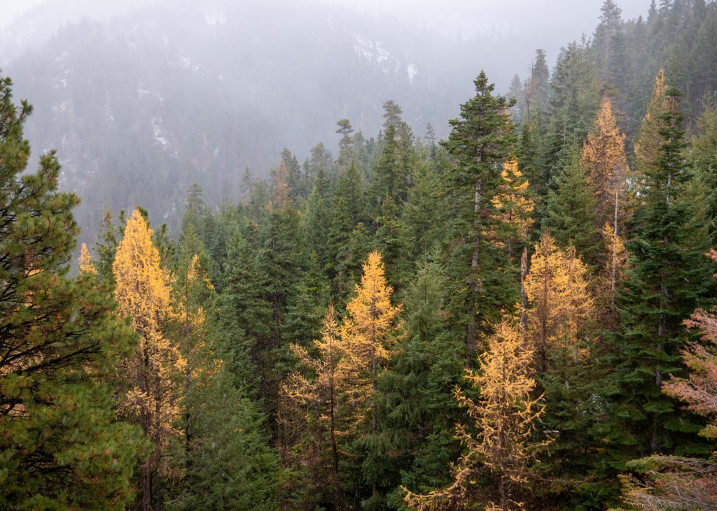
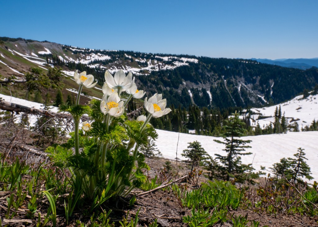
While navigating the snow provided for extra challenges, we encountered a couple Mount Rainier volunteers on the trail who educated us on the importance of hiking in the snow, and not being tempted to step into the meadows where the snow had already melted, as this is damaging to the plants trying to recover after a long, cold winter. We were even lucky enough to see some wildflowers starting to bloom!

Wildflowers starting to bloom!

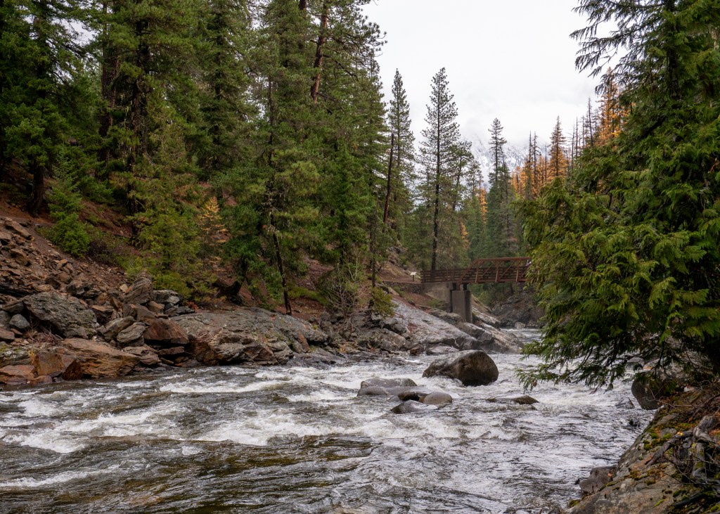
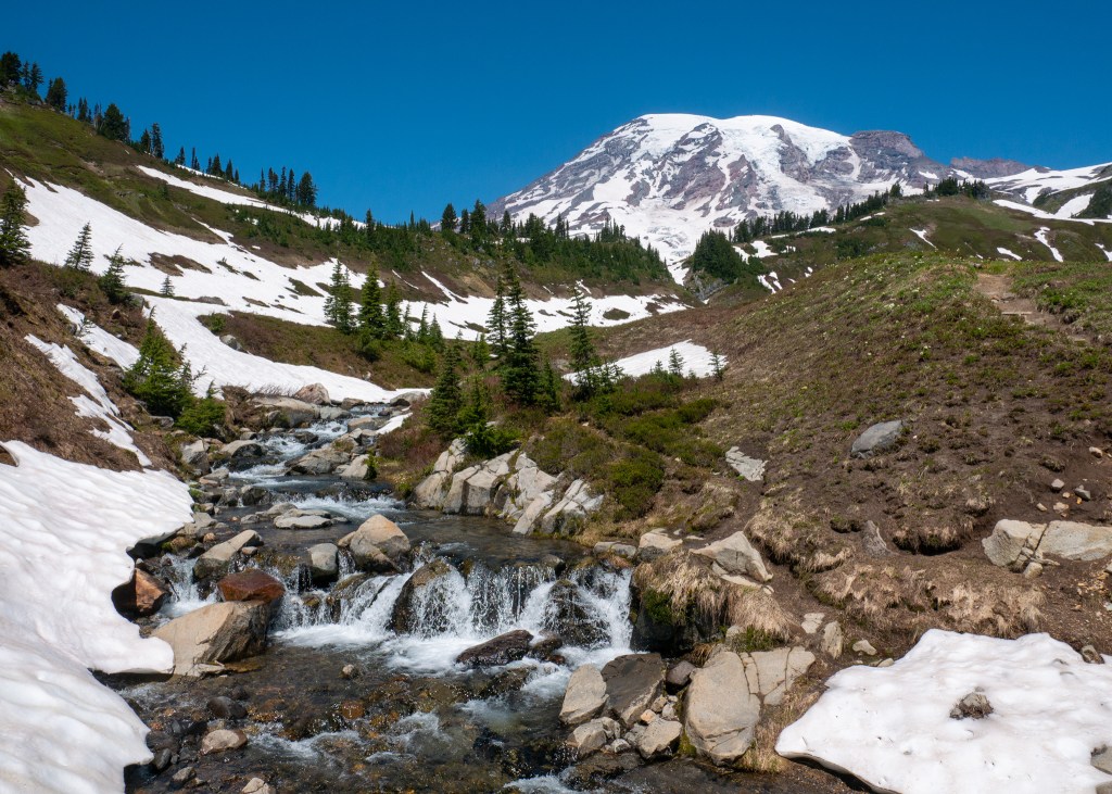
Mountain views, marmots and wildflowers were not the only sights that the Skyline Loop offered – we also passed several water streams during the hike and saw another waterfall – Myrtle Falls – near the end of the trail. The waterfall area is very busy, as many visitors will start the Skyline Loop trail in the opposite direction, and some will even turn around after Myrtle Falls, as it is located only a short walk from the Visitor Centre.

Myrtle Falls, with Mount Rainier in the background

Overall, we very much enjoyed this hike – it is not surprising that the Skyline Loop Trail is considered the top hike in Mount Rainier National Park – we were surrounded by beautiful sights of nature and 360 degree mountain views for a little over 4-hours – what else can you ask for?

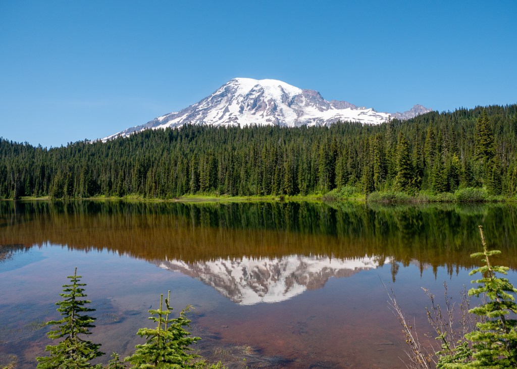
After completing the Skyline Loop Trail, we had lunch and grabbed a couple of souvenirs from the Visitor Centre (a colour poster with marmots, obviously ツ, and a magnet) before making our way to Reflection Lake. The Lake is appropriately named, as you are able to see a reflection of Mount Rainier in the water. It was stunning!

Self-explanatory ツ

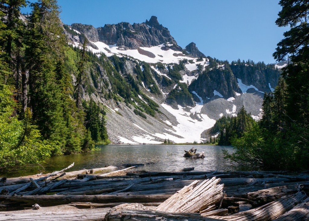
From here, we somehow found the energy to take on one more short, easy hike called the Bench and Snow Lakes Trail. This trail is 3.5km in length, has an elevation gain of 139m, and AllTrails suggests that it takes around an hour to complete. 

As the name suggests, you will encounter two lakes along this trail, starting with Bench Lake. This was a beautiful lake, providing more views of Mount Rainier, because let’s face it, you cannot get tired of this sight. However, we preferred the views at Snow Lake, but only because it provided us with something new to see. 

Bench Lake

While walking towards Snow Lake, you will encounter a fork on the trail, and there will be a sign that indicates the direction for the camp sites – go left at the fork towards the campsites, as this area provides better views (in my opinion) of Snow Lake. My favourite vantage point was actually along the log that you need to cross to get to the camping area – the logs in the lake provided some beautiful foreground for photos, as we took in the sights of Snow Lake.

While the lakes were beautiful, the biggest downside to this trail was the bugs. While I did not think that the bugs were landing on me, they were just flying near me, I was wrong – I ended up with 7 new bites from this hike! I think they were mosquito bites, but I cannot be certain. Make sure to put on bug spray or wear loose clothing if you attempt this hike.

After completing the Bench and Snow Lakes Trail, we decided we were done with hiking for the day and started to make our way back to Ashford. Before going back to our Airbnb, we stopped at Rainier Basecamp Bar & Grill for a refreshing beverage – this was a cool spot to enjoy a drink after a long day of exploring, as it had great vibes and a massive patio, but they clearly had a busy day as they ran out of certain items on the menu!

Overall, we really enjoyed our short visit to Mount Rainier National Park, and look forward to returning one day to explore more areas of this beautiful landscape.

Always grateful,

Michelle

Back to the PNW – Olympic National Park

I used to think that going six weeks in between blog posts was a long time, but now it has been five months since my last post! Life has been incredibly busy lately, and while I have started writing several new posts, I have not been able to finish one.

We have had a couple exciting adventures since my last blog post in February – we spent some time in Los Angeles, Jaco (in Costa Rica), on Vancouver Island, and most recently in Olympic National Park in Washington. I am going to share all my thoughts about Olympic National Park now while everything is still fresh in my head!

Olympic National Park is around a four-hour drive from where we live, making it a great option for a quick weekend trip. This is our 9th National Park visit in the United States, and it definitely did not disappoint! I actually bought a scratch off poster last year to track all the parks we have been to, but I am currently behind on this activity (being behind on things appears to be a common theme in my life right now…).

In order to explore Olympic National Park, we decided to stay in Port Angeles, which is the largest city near the park. We stayed in an Airbnb in a quiet neighbourhood with our friends, Iwona and Craig. The highlight of this location for me was all the deer (including the babies!) roaming the streets and nearby trails.

We did not spend too much time in Port Angeles, itself, but here are some notable shops and food establishments we checked out:

  • Our favourite restaurant was New Day Eatery. While I did not try the coffee here, I was advised by Justin, Iwona and Craig that this was their favourite coffee stop of the trip. New Day Eatery also had several plant-based (and gluten free) baked goods – it was actually difficult to make a decision due to all the options! Different scones, muffins, coffee cakes… if only calories were not a concern. We also had breakfast here on our last morning, and it was delicious.
  • A shoutout to Westside Pizza for offering vegan cheese – loved the vegetarian pizza option!
  • We all picked up our local swag at MOSS. I usually try to limit myself to one item, but I could not make a decision (apparently another common theme in my life). I ended up getting the Washington Nature Checklist t-shirt, and Iwona and I are also the newest members of the Out of Breath Hiking Society with our new hats. If you are hoping to pick up some Pacific Northwest gear, definitely stop by MOSS.
  • While we did not make any purchases, we enjoyed browsing the gift items, games and books at Port Book and News.

We essentially had two full days to explore the park, plus some time in the evening the day we arrived. One thing that makes Olympic National Park unique is its diverse ecosystem which is made up of the coast, forests and mountains. Since our daylight was limited on our first (partial) day, we settled on exploring a shorter trail amongst the forests – the Marymere Falls Trail.

This was a very peaceful and easy hike – we loved walking amongst the tall trees, breathing in the fresh air and listening to the water flow in the nearby creek. I would definitely recommend doing this hike later in the day if this is an option for you, as the light scattering through the trees onto the trail was beautiful.

Marymere Falls

Moving onto our first full day at the Park, we decided to drive out to the Washington coast to explore the beaches that make up Olympic National Park. Our first stop was at Cape Flattery, which was around an hour and 45 minutes from Port Angeles. Note that this area of the park is managed by the Makah Indian Tribe and visitors must pay an additional $20 USD entrance fee, on top of the National Park fee. In order to reach the beautiful cliff overlooking Neah Bay, you have to walk along a short, tree-covered trail – the trail out-and-back is less than 2kms. There are a couple of different view points once you get to the end, and all of them are spectacular!

The views from Cape Flattery

Our next stop was Shi Shi Beach, which was a 20-minute drive south from Cape Flattery. On AllTrails, you will find a 14km Shi Shi Beach Trail, but to actually get to the beach, it is around 3.5km. The trail to the beach was through the forest, and it was more muddy than we expected – I would definitely recommend hiking or waterproof shoes for this trail… leave your white sneakers at home ツ. Craig had actually seen a sign in the beach parking lot that made reference to the number “0.6,” leading us to believe this trail was 0.6 miles. You can imagine how surprised we were to have walked a total of 7km (out-and-back). But, upon returning to our vehicle, we realized the 0.6 miles was actually referring to the next parking lot for campers – oops!

While Shi Shi Beach appeared to be a beautiful spot, we were very limited in what we were able to see, as there was a lot of fog and low cloud coverage – I actually kind of enjoyed the eerie atmosphere ツ.

A moody version of Shi Shi Beach

Our final destination along the coast was Rialto Beach. This Beach was about an hour and 20 minutes away from Shi Shi Beach, and was just outside the city of Forks. Many people are familiar with Forks, as this is where all the Twilight movies were filmed – I personally had no idea as I am not a Twilight fan. Even though the series was filmed over 15 years ago, the town is not shy about capitalizing on this moment – you can find vampire swag in the shops in Forks, and the town refers to itself as “Home of the Twilight Saga.”

Blood-sucking mythical creatures aside, Rialto Beach is easily the nicest beach I have ever seen. When we initially got here, similar to Shi Shi Beach, it was quite foggy and actually very cold and windy! Have I mentioned that Justin did not bring a sweater or jacket on this trip ツ? Our plan was to walk along the beach towards the Hole-in-the-Wall rock structure (which is located about 2.5km one way from the parking lot), but unfortunately, the tide was too high and we did not make it to the end – but, we still got pretty close!

However, during our walk, the fog lifted and we were able to see the beach for miles – it was beautiful. My favourite part about this entire experience was the abundance of drift wood along the beach, which made for very cool photo opportunities, as well as the pelicans flying along the coast and diving for fish! Although, one thing I was surprised about was how tired I was from this walk – 5kms through the sand and rocks is no joke!

Rialto Beach after the fog lifted, featuring some pelicans!
Another photo of Rialto Beach – can you spot the Hole-in-the-Wall we were trying to reach?

After finishing up at Rialto Beach, and grabbing a bite to eat at Blakeslee Bar and Grill, it was time to drive back to Port Angeles, which was about 1 hour and 20 minutes away. Needless to say, we did a lot of driving on this day, but it was definitely worth it!

After touring the forests and coast, the last ecosystem we had left to explore within the Park (and it was also our last day) was the mountains, and our trail of choice was Hurricane Hill via Hurricane Ridge. In order to get to this trail head, you need to drive about 40-minutes through the park along a switchback road, up to an elevation of 5,252ft. Note that there are only three small parking lots near the start of the trail and they fill up quickly – we arrived around 9:30am and had to park at the furthest lot.

Despite the limited parking situation, I cannot say enough good things about this trail. The picturesque mountains, the colourful wildflowers and the views of Vancouver Island from the top were incredible. If you only have time for one hike in the park, I would put this at the top of your list!

Views from the top of Hurricane Hill – can you spot Mt. Baker?
Mountain views and wildflowers along the Hurricane Hill via Hurricane Ridge trail

In terms of difficulty, I would rate this hike as moderate – while it is fully paved, there is an elevation gain of 252m over 2.75km, which results in some steeper sections along the trail. If you struggle with downhill, I would definitely recommend bringing some hiking poles. The trail is also fully exposed – there are very few trees to provide shade.

After taking a lunch break to watch the EuroCup Final, we decided to finish our day in the forest with an easy walk around Crescent Lake along the Spruce Railroad Trail. We did not have enough time to complete all 18km, but we enjoyed the first part of the trail, stopping to sit by the lake to take in the Olympic National Park views one last time.

Views of Crescent Lake

Overall, we are very happy with our time spent in nature at Olympic National Park and we are already starting to plan our next National Park visit! Where should we go?

On a completely unrelated note, I am thinking about starting an Instagram account to showcase some of my travel photos. What do you think – should I do it? Do I have time, or will it just become another activity I am behind on ツ?

Until next time!

Always grateful,

Michelle

The Pacific Northwest

Back in November, Justin and I had the chance to spend an extra long weekend doing some exploring in the beautiful Pacific Northwest with our friends Iwona and Craig. Specifically, we spent time down in Washington in Leavenworth and Wenatchee.

The drive from the Canadian border to the Wenatchee/Leavenworth area is around 4-hours, but we managed to stretch this into a 7-hour drive by making several stops for lunch and coffee, and at Trader Joe’s.

One thing I have never mentioned in any of my previous blog posts is that when we are travelling in the US, we try to book accommodation with a kitchen (or at least a decent sized fridge) as our very first stop in every new city is Trader Joe’s. We always stock-up on the premade salads, wraps and snacks as this helps to keep the food portion of our trip cost effective, and it helps us eat healthier. Well, our trip down to Washington was no different ツ!

We ultimately had two full days in Wenatchee and Leavenworth, and during this time, we were able to fit in two hikes, as well as some time to explore the nearby towns and shops. Our first hike was a trail surrounding Clara Lake and Marion Lake in the Okanogan-Wenatchee National Forest, which was around 30-minutes from our accommodation in East Wenatchee. The reason we picked this hike is because some reviews we read suggested we might still be able to see larches in the area, even though it was already mid-November.

Well, to our surprise, we did find larches on our drive to the start of the trailhead, but there were definitely no larches on the trail, itself, as it was covered in snow! Fortunately, we showed up prepared with crampons and ice cleats to help us enjoy our hike through the winter wonderland.

The larches we saw when driving to the Clara and Marion Lakes trailhead

As we were hiking along the trail, we remained hopeful that there might be more larches at the end of the hike. We decided to ask the first person we encountered whether there were larches by the lakes, and he laughed and said “sure.” He either did not know what larches were, or we missed the sarcasm in his response – he definitely got our hopes up! Either way, we will have to go back to this trail one day, hopefully a bit earlier in the year to see the larches and to see Clara and Marion Lakes without all the snow.

Up close and personal with the larches!

The other trail we did was the Icicle Gorge Trail, which is also part of the Okanogan-Wenatchee National Forest. This trail was actually closer to Leavenworth, and was around an hour away from our accommodation. To our surprise, the entire area surrounding the trail was surrounded by larches! I later learned that there are actually multiple types of larches, and I believe the ones we saw were western larches, which can be found in lower elevation areas (compared to alpine larches, which grow at high elevations).

While I would definitely consider the Icicle Gorge Trail to be an easy nature walk, it was a stunning walk along the river – I would highly recommend putting this on your must see list when visiting Leavenworth.

Icicle River along the Icicle Gorge Trail
Larches surrounding the Icicle Gorge Trail

Other than our time outdoors, we also made a point of checking out the local restaurants in the area. While we were in Wenatchee, we went to Wenatchee Valley Brewing to enjoy a local beer and some snacks, and also checked out Tap and Putt, which offers games and indoor mini-golf in addition to food and drinks. We ended up playing shuffleboard, and also three rounds of Monopoly Deal (which I brought from home), and we could not believe that Craig won every single game. It would not be incorrect to say I get a little bit competitive when playing Monopoly Deal.

In terms of eating establishments in Leavenworth, we enjoyed a Mexican lunch at South Leavenworth, dinner and live music at Yodelin (I definitely regret not trying one of their soups) and played a couple more rounds of Monopoly Deal over a drink at the Icicle Brewing Company. While I was not able to completely redeem myself over Monopoly Deal this time, thankfully I won one game ツ.

Views from the town of Leavenworth – on the left is one of the Bavarian-style buildings

I should note that our trip to Leavenworth was during the shoulder season and I would love to visit again one day in the winter. In case you did not know, Leavenworth goes “all out” for Christmas – thousands of decorative lights, live music, carolers and, of course, a special appearance from Santa, himself.

I know this was one of my shorter blog posts, but hopefully it gives you some ideas on what to do if you are ever visiting Wenatchee or Leavenworth!

Always grateful,

Michelle